
Tucson AccessTrails
Explore Regional Trails and Parks
TEST SITE - WORK IN PROGRESS
Sabino Canyon Recreation Area Phoneline Trail
TEST SITE - WORK IN PROGRESS

Trail Facts at a Glance
Name: Phoneline Trail, in Sabino Canyon Recreation Area
Parks agency: Santa Catalina Ranger District, Coronado National Forest
Contact: 520-749-8700 or sm.fs.scrd@usda.gov
Location: 5700 N. Sabino Canyon Road
The southern trailhead is most easily accessed by walking 0.75 miles from the parking lot, along Lower Sabino Canyon Road, to the sign marking the beginning of the Phoneline Trail.
The northern trailhead is most easily accessed by taking the Sabino Canyon Shuttle from the Visitor Center to Stop #9 (3.7 miles) and following signs to the Phoneline Trail
Parking fee: Day-use fee $8/day and $10/week or free with Interagency, Military and Coronado passes
Trail hours: Sabino Canyon Recreation Area, open 24h/day 7days/week
Sabino Canyon and Bear Canyon Shuttles (“The Crawler”), 7 days/week
(closed Thanksgiving, Christmas and 3 days for maintenance)
May 1 to Dec 14, 9am to 4pm, departures every hour
Dec 15 to April 30, 9am to 4pm, departures every half hour
Visitor Center hours: Open 7days/week, 8am to 4:30pm
(closed on Thanksgiving and Christmas)
Transit: None
Trail length plus more: Four routes are recommended:
South-to-North-to-South Loop: 4.4 miles (least difficult), Gain
North-to-South Route: 4.4 miles,
End-to-End One-Way Route: 5.4 miles, Gain 510’, Loss 1120’, Elevation 3200’
End-to-End Round-Trip Route: 10.8 miles (most difficult)
Trail surface: Rugged natural surface with rocks, sand, stairs and grades > 10% with steep drop-offs, narrow sections, switchbacks and stream crossings
Date of last visit: 3 December 2024

Enjoy a 2-minute virtual visit to enhance your trail experience

Description:
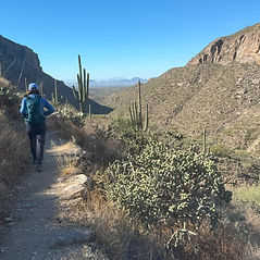
The Phoneline Trail in Sabino Canyon has all the best aspects of hiking in Tucson. It provides spectacular up-close views of the Santa Catalina Mountains and panoramic vistas of the city of Tucson. The trail is lined with wildflowers in Spring, cactus flowers in Summer, and golden cottonwood leaves in Autumn; hikers share the trail with white-tail deer and Gila monsters; and the hike passes through colorful rock formations formed in an uplift millions of years ago.
The trail is also uniquely situated to offer what few other trails in Tucson can: shade. The trail is cut along a west-facing cliff. So, an early morning hike is in full shade for 50-70% of its length, depending on the season.
However, the Phoneline Trail also has all the worst aspects of Tucson hiking. The trail traverses steep rock faces with lengthy switchbacks; the hiking surface is a stumblefest of boulders, sand, gravel and rock staircases; and at times, the path narrows to a body width next to a vertical 100’ drop-off. After a storm, hikers can expect precarious stream crossings.
Those difficulties are somewhat offset by the trail’s flexibility. The Phoneline Trail stretches the length of the Sabino Canyon Recreation Area and runs parallel to Upper Sabino Canyon Road where an hourly shuttle runs up and down the canyon. Therefore, hikes on the Phoneline Trail can be designed for a 5.4-mile one-way uphill-or-downhill route by riding the shuttle to the top or bottom of the trail. Or the trail can be hiked as a 4.4-mile loop starting in the parking lot and traversing off the Phoneline trail to the shady Sabino Creek Trail. Or hikers can plan for a round-trip 10.8-mile hike, and on a mid-hike whim, can cut back to a 3-mile route by dropping down to a shuttle stop for a ride back to the parking lot.
The amenities are plentiful at the Sabino Canyon Visitor Center - accessible parking, restrooms, drinking fountains, and a gift shop and museum - but there are no restrooms or benches along the Phoneline Trail. Nonetheless, hikers on the Phoneline Trail feel safe alongside many fellow hikers and USFS volunteers who patrol the trail.
So, for your next family reunion, when you want to show off the natural beauty of Tucson to your adventurous grandmother, your urban sister, and your triathlete niece, consider a morning hike on the versatile Phoneline Trail.
Photo Tours by Topic (click on photo for tour)
Overview

Trail Characteristics

Location and Arrival
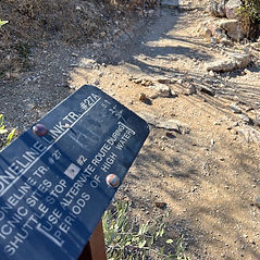
Signage and Wayfinding

Amenities and Features

Operations and Maintenance
Click on map or legend to see enlarged view


Disclaimer: The information provided is for general guidance only and may not reflect current conditions. Users must assess trails for themselves, consider their own abilities, and assume all risks associated with trail use. Tucson AccessTrails, a nonprofit corporation, is not responsible for any injuries or incidents that may occur. Always use caution and prepare appropriately when visiting trails.